Trail Walking La Roquebrussanne - La Roquebrussanne dec 2023 - Photo
 ETMU5496
ETMU5496

User

© OpenStreetMap contributors
Length
Length
19.2 km
Max alt
Max alt
818 m
Uphill gradient
Uphill gradient
875 m
Km-Effort
Km-Effort  
31 km
Min alt
Min alt
386 m
Downhill gradient
Downhill gradient
877 m
Boucle
Boucle
Yes
Creation date :
2023-12-13 07:52:13.0
Updated on :
2023-12-14 15:08:12.989

(0 Reviews)

Walking
Walking
7h00
Difficulty : Difficult

Scan this QR Code to open this trail in the SityTrail application

FREE GPS app for hiking

Logo SityTrail SityTrail

IGN / Geographical institutes

Download SityTrail from the App Store Download SityTrail from Google Play

Logo SityTrail SityTrail Plus

The world is yours!

Download SityTrail from the App Store Download SityTrail from Google Play Download SityTrail on Huawei AppGallery

About

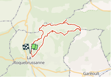
Trail Walking of 19.2 km to be discovered at Provence-Alpes-Côte d'Azur, Var, La Roquebrussanne. This trail is proposed by ETMU5496.

Description

La Loube, montagne sauvage et atypique du Centre-Var où se trouvent des lieux superbes magnifiés par de vastes panoramas.

Départ de La Roquebrussanne, village du Val d'Issole, pour découvrir chapelles, grottes, tour,  pas d'escalade et sentiers escarpés au milieu des dolomies aux formes variées.

IBP=86

Elevation profile

Photos

28 photos in total. Please click on a photo to see them all in the gallery.

Positioning

Country:
France
Region :
Provence-Alpes-Côte d'Azur
Department/Province :
Var
Municipality :
La Roquebrussanne
Location:
Unknown
Start:(UTM)
741359 ; 4803458 (31T) N.


Close
My subscriptions